JEWISH KING JESUS IS COMING AT THE RAPTURE FOR US IN THE CLOUDS-DON'T MISS IT FOR THE WORLD.THE BIBLE TAKEN LITERALLY- WHEN THE PLAIN SENSE MAKES GOOD SENSE-SEEK NO OTHER SENSE-LEST YOU END UP IN NONSENSE.GET SAVED NOW- CALL ON JESUS TODAY.THE ONLY SAVIOR OF THE WHOLE EARTH - NO OTHER. 1 COR 15:23-JESUS THE FIRST FRUITS-CHRISTIANS RAPTURED TO JESUS-FIRST FRUITS OF THE SPIRIT-23 But every man in his own order: Christ the firstfruits; afterward they that are Christ’s at his coming.ROMANS 8:23 And not only they, but ourselves also, which have the firstfruits of the Spirit, even we ourselves groan within ourselves, waiting for the adoption, to wit, the redemption of our body.(THE PRE-TRIB RAPTURE)

SIGNS IN THE SUN, MOON AND STARS-CHEMICAL WEAPONS
LUKE 21:11
11 And great earthquakes shall be in divers places, and famines, and pestilences;(BIOLOGICAL/CHEMICAL/NUCLEAR) and fearful sights and great signs shall there be from heaven.
LUKE 21:25-26
25 And there shall be signs in the sun,(HEATING UP-SOLAR ECLIPSES) and in the moon,(MAN ON THE MOON-LUNAR ECLIPSES) and in the stars;(ASTEROIDS-PROPHECY SIGNS) and upon the earth distress of nations, with perplexity;(MASS CONFUSION) the sea and the waves roaring;(FIERCE WINDS)
26 Men’s hearts failing them for fear,(TORNADOES,HURRICANES,STORMS) and for looking after those things which are coming on the earth:(DESTRUCTION) for the powers of heaven shall be shaken.(FROM QUAKES,NUKES ETC)
REVELATION 16:21 80-120LB HAIL ON HUMANS
21And there fell upon men a great hail out of heaven, every stone about the weight of a talent:(80-120 LBS) and men blasphemed God because of the plague of the hail; for the plague thereof was exceeding great.
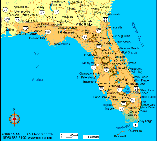
Hurricane Ian live updates: Ian might be deadliest in Florida history, Biden says-Ian made landfall near Cayo Costa, an island off the coast of Fort Myers.ByJulia Jacobo,Teddy Grant,Kevin Shalvey,Emily Shapiro,Melissa Gaffney,Meredith Deliso,Jon Haworth, andNadine El-Bawab-Last Updated: September 29, 2022, 5:37 PM
Sep 29, 5:37 PM EDT-Ian is once again a Category 1 hurricane-Hurricane Ian is a Category 1 storm again as of early Thursday evening, with winds now at 75 mph.Ian will keep strengthening and head north before taking a slight northwest turn into South Carolina. The National Hurricane Center track takes it almost directly into Charleston Friday during the early afternoon.This would be the third mainland landfall of Ian -- first in Cuba, then in Florida, which technically had two landfalls on Wednesday, the first on Sanibel Island at Cayo Costa and the second at Punta Gorda.-ABC News' Melissa Griffin and Daniel Amarante-Sep 29, 5:11 PM EDT-At least 9 dead in hurricaneAt least nine people have now been reported dead in Florida due to Hurricane Ian.Charlotte County Commissioner Chris Constance confirmed there are six fatalities in that county. Constance said this is the worst storm damage he has ever seen.Two deaths have also been confirmed in Sarasota County.One death was recorded in Volusia County when a 72-year-old man trying to drain his pool was washed away by floodwaters.-ABC News' Will Gretsky-Sep 29, 4:41 PM EDT-Hundreds rescued from flooding across Florida-More than 500 people have been rescued in Charlotte and Lee counties since rescue operations began Thursday morning, Florida's Division of Emergency Management said. Search and rescue operations are still ongoing in those two counties.There have been about 350 people rescued so far in Orlando, officials said. Among those were 106 people rescued from an Avante Group nursing home.The city received 14 inches of rain from the storm, according to Orlando Mayor Buddy Dyer, overflowing lakes and flooding neighborhoods in the inland city.Residents are rescued from floodwaters in the aftermath of Hurricane Ian in Orlando, Fla...The U.S. Coast Guard had rescued more than 30 people over the last 24 hours, according to Adm. Linda Fagan."We live in these same communities that we're now responding to and supporting," Fagan told ABC News. "The Coast Guard workforce is really at its best in times like these, as we respond as an immediate, first-response agency."FEMA Urban Search and Rescue teams are also assisting in search and rescue efforts, checking homes and gathering information on buildings hit by Hurricane Ian, Jeremy Edwards, FEMA press secretary, told ABC News.Search and rescue teams from Ohio, Indiana and Texas are searching and surveying the Tampa Bay area, while two teams from Virginia are in Punta Gorda, according to Edwards.-ABC News' Victoria Arancio-Sep 29, 4:05 PM EDT-Lee Health evacuating 3 of 4 hospitals due to lack of running water-Lee Health, the Florida-based health care system, has evacuated patients out of three of its four hospitals because they don't have running water due to Hurricane Ian, Dr. Larry Antonucci, president and CEO, said in a video statement Thursday.“At the present time, our structures and facilities are in good shape. They’ve weathered the storm well, but our infrastructure is challenged in the way of our water supply and power,” Antonucci said.Lee Health is working with the Agency for Health Care Administration in Florida and local emergency management to arrange for the evacuations of patients to other hospitals outside of Lee County, which includes Fort Myers.-ABC News' Alexandra Faul
UPDATE 6:00AM SEP 29,2022-IAN IS NOW A TROPICAL STORM IN FLORIDA HEADING TOWARDS ORLANDO. 2.5 MILLION ARE CURRENTLY WITHOUT HYDRO. WE WILL SEE ALL THE DAMAGE DONE NOW THAT ITS GETTING LIGHT.
It's 6 a.m. in Central Florida. Here's the latest as Tropical Storm Ian moves north
Ian remains a dangerous tropical storm as it carves its way through central Florida Thursday morning with winds of 65 mph and higher gusts.Ian first made landfall in southwestern Florida as a devastating Category 4 hurricane Wednesday afternoon and weakened overnight. It is now expected to exit the state through Florida's northeast coast on Thursday and approach the coasts of Georgia and South Carolina on Friday.The storm has left catastrophic damage in its wake. In addition to hurricane-force winds, storm surges have slammed into coastal communities and torrential rains brought dangerous flooding that left some residents trapped in their homes.Here are the latest developments:Many residents are without power: More than 2.5 million customers in Florida have lost power as of Thursday morning, mostly in the state's southwest and central regions, according to outage tracker PowerOutage.us. Multiple counties in southwestern Florida are reporting near-total blackouts due to damage sustained, and the Tampa-St. Petersburg metro area has also been heavily affected.Central Florida is inundated with rainfall: The area has already received total rainfall amounts of 8 to 12 inches and an additional 2 to 4 inches are expected. Heavy rain will continue to produce life-threatening flash flooding.Southern Florida no longer under weather warnings: Hurricane and tropical storm warnings across southern Florida have been dropped as the storm moves farther north, according to the National Hurricane Center. Water levels along the state's west coast are also continuing to subside.Southeastern states prepare for Ian's arrival: Georgia, Virginia, North Carolina and South Carolina are bracing for the storm's impact, with all four governors declaring states of emergency. 3 hr 28 min ago-Fire rescue teams in Lee County begin answering calls for assistance as storm subsides-From CNN's Rebekah Riess-Fire rescue crews in Estero, a town in southwestern Florida's Lee County, has started to clear streets and respond to calls for help that they were unable to answer during the storm, according to the town's fire department.“We began clearing roadways and evacuating those that needed help,” Estero Fire Rescue said in an update.“Please help us by staying off the roadways. We will be getting help from multiple agencies tomorrow and throughout recovery and they need to make sure the roads are safe, trees are removed and wire(s) aren't down. It is still very dangerous out there.”Multiple first responder and law enforcement agencies have reported being unable to answer emergency calls as massive floods restricted access to those in need.3 hr 10 min ago-Ian weakens to a tropical storm, still expected to produce substantial storm surge and rain-From CNN's Robert Shackelford and Travis Caldwell-Ian has weakened to a tropical storm with winds of 65 mph and higher gusts, according to the 5 a.m. update from the National Hurricane Center.Tropical Storm Ian is still expected to produce strong winds, heavy rains, and storm surge across portions of Florida, Georgia, and the Carolinas over the next 3 days, the center said.A storm surge warning is in effect for the St. Johns River in northeast Florida, as well as areas stretching from the Flagler-Volusia County line in Florida north to the South Santee River in South Carolina. Portions of the Gulf Coast also remain under storm surge threat.Tropical storm warnings have been issued for much of Florida's Gulf Coast, from north of Bonita Beach up to Indian Pass along the Panhandle.Areas stretching from Boca Raton to Cape Lookout, North Carolina, also face a tropical storm warning, as does Lake Okeechobee. Some isolated hurricane-force winds may still occur.4 hr 13 min ago-Tampa Bay Buccaneers practice in Miami and talk about Hurricane Ian's impact-From CNN's Ben Morse, Wayne Sterling and David Close-After relocating due to Hurricane Ian and practicing in Miami Gardens on Wednesday, players and coaching staff for the NFL's Tampa Bay Buccaneers spoke about the effect the storm has had on them and their families, and expressed their well-wishes to those impacted by the storm."First of all, our thoughts and hearts go out to everybody in Tampa that's still there, hoping that they recover well and it doesn't hit them very hard," Bucs head coach Todd Bowles told reporters.Running back Leonard Fournette, who was born in New Orleans, remembered the impact and devastation Hurricane Katrina had when it hit the Gulf Coast in 2005 and took the lives of 1,833 people."I've been through Katrina, as a kid," Fournette said. "I know how severe and serious it is ... I just thank God that we got out there and we're just praying for the families up there in Tampa."4 hr 28 min ago-Punta Gorda's water system is empty and boil water notices are in effect, city says-From CNN's Rebekah Riess-The Punta Gorda city water system is empty and boil water notices are in effect following the impacts of Hurricane Ian, according to an update from city officials late Wednesday. The water system is "pumping at a rate of over 13 million gallons per day and cannot keep up,” the city said.A fill station is being set up for residents at the city’s water plant, and the system will be restarted once damaged pipes are repaired, the update said.Punta Gorda is the county seat of Charlotte County, which is reporting more than 90 percent of its customers without power, according to PowerOutage.us.4 hr 58 min ago-Local rescue teams are sidelined by dangerous conditions as trapped residents call for help, officials sayFrom CNN's Jamiel Lynch, Amanda Musa and Amy Simonson-Rescue and emergency response missions have been delayed in some heavily-impacted parts of Florida because of risky storm conditions, state and local officials said.In Charlotte County, Emergency Management Director Patrick Fuller said Wednesday night that emergency response teams there will not be able to answer calls for help "until the hazards conditions end." Officials hopes to resume responses Thursday morning.Other counties have been inundated with emergency calls, with the Collier County Sheriff's Office saying they are in "triage mode.""We are getting a significant number of calls of people trapped by water in their homes,” the office said in a statement Wednesday. “Some are reporting life threatening medical emergencies in deep water. We will get to them first. Some are reporting water coming into their house but not life threatening. They will have to wait. Possibly until the water recedes."First responders in Fort Myers are now out surveying the damage, according to the Fort Myers Fire Department early Thursday morning. “Crews have reported back with debris in the roadways, flooding, electrical lines down, power poles in the roads, traffic lights out, disabled vehicles, and building collapses,” the department said, asking for residents to remain indoors.Gov. Ron DeSantis cautioned in a press conference Wednesday that 911 calls may not be answered right away in some areas. “Local first responders will deploy as soon as it’s safe to do so,” DeSantis said, adding, “By and large until the storm passes, they are not going to go into a situation for rescue and put their own folks at risk."5 hr 30 min ago-High waters flood TV news station in Fort Myers-From CNN's Dave Alsup-Floodwaters from Hurricane Ian inundated the set and newsroom at Fort Myers-based CNN affiliate WINK TV.WINK Chief Meteorologist Matt Devitt posted on social media, “Storm surge got into WINK, flooded out our entire set and newsroom in Fort Myers. Lost power and I was unable to continue broadcasting on tv and radio.”An update on the station's website indicated its newscast went off air during the brunt of the storm Wednesday afternoon. “Storm surge and a flood brought by Hurricane Ian has interrupted the WINK News broadcast. The power went out just before 5 p.m., but anchors Lois Thomas and Chris Cifatte and Chief Meteorologist Matt Devitt continued to broadcast on Facebook for a period of time,” according to the station's website.“We are like everybody else,” said Tom Doerr, director of local news and content at WINK News. “We are experiencing the same difficulties like everybody else.”5 hr 49 min ago-Considerable flood threat continues for areas of Florida-From CNN's Mike Saenz-Flash flood warnings have been extended until 4:45 a.m. ET for parts of Osceola County and adjacent Orange County, Florida, the National Weather Service in Melbourne said early Thursday.In the Orlando metro area, law enforcement reports flooding due to heavy rain. The area has already received a total rainfall of 8 to 12 inches and an additional 2 to 4 inches are expected. Heavy rain will continue to produce life-threatening flash flooding.When driving, “be especially cautious at night when it is harder to recognize the dangers of flooding” the National Weather Service says.Remember: "turn around, don't drown" when encountering flooded roads.
UPDATE 9:00PM SEP 28,2022-ITS BEEN A LONG DAY OF FIERCE WINDS, HIGH WAVES AND 1.8 MILLION WITHOUT POWER THROUGHT OUT FLORIDA.
Bloomberg-Hurricane Ian Latest: Cuba Migrant Boat Sinks Off Florida, 23 Missing-Brian K. Sullivan and Will Wade-Wed, September 28, 2022 at 8:09 p.m
(Bloomberg) -- Hurricane Ian barreled ashore in southwest Florida with a massive and deadly surge of water and catastrophic winds that are poised to make it one of the costliest storms in US history.The Category 4 hurricane made landfall west of Fort Myers near Cayo Costa shortly after 3 p.m. local time. Nearly all of Florida, home to 21 million people, braced for widespread blackouts and floods. More than 2 million people have been ordered or urged to flee. The storm is expected to cause more than $67 billion in damages and losses.“This is going to be a tragic event,” Florida Governor Ron DeSantis said during a briefing as the storm neared shore. “It’s something that is going to be there for days, weeks, months and unfortunately in some circumstances even years.”A storm of this magnitude is a severe test for Florida’s infrastructure due to its low-lying and densely populated coastal areas that are prone to flooding. It comes as climate change has fueled extreme weather worldwide this year, including deadly flooding in Kentucky and Pakistan, a European heat wave that killed more than 2,000 people in Portugal and Spain, and relentless drought in the US west.Time stamps are Eastern Standard.1.8 Million in Dark as Hurricane is Downgraded (8 p.m.)-Nearly 1.8 million homes and businesses were without power Wednesday evening as Ian continued to batter the Florida peninsula.The storm had cut power to nearly all residents in three counties in the southwest corner of the state that took a direct hit, according to PowerOutage.us.At 8 p.m. local time, the storm’s winds were at 115 miles per hour (185 kilometres), making it a Category 3 hurricane, the National Hurricane Center said. The center of the storm was about 95 miles southwest of Orlando.Ian’s maximum winds were at 150 miles per hour when it made landfall.Storm Threatens to Spur Tornadoes in Battered Florida (5:20 p.m.)Tornado watches have been issued in East Central Florida until 1 a.m. ET as Ian rips through the region.“You should make the same preparations as if it is a tornado going over your house,” said Kevin Guthrie, director of the Florida Division of Emergency Management, during a Wednesday briefing. “Get into an interior room free of windows and have stuff to be able to protect your head and body from debris such as a blanket, mattress or even a helmet.”Cuba Migrant Boat Sinks Off Florida, 23 Missing (5:04 p.m.)-The US Coast Guard said it’s searching for 23 missing migrants near the southern tip of the Florida Keys after their boat sank while Hurricane Ian hammered the Gulf Coast.In a series of tweets, the US Coast Guard said at least four Cuban migrants were able to swim to shore near Stock Island -- just north of Key West -- after their boat sank “due to inclement weather.”Cuban migration to the US has hit a decade-long highs as the communist island is mired in economic turmoil and power outages.Ian churned across Western Cuba Tuesday, knocking out power to the entire island before making its way to Florida.More Than 1 Million Without Power In Storm’s Wake (4:44 p.m.)-More than 1 million homes and businesses are now without electricity as Hurricane Ian barrels inland, ripping down power lines and uprooting trees.More 70% of customers are without power in Lee County, where the eye of the hurricane roared ashore shortly after 3 p.m. Neighboring Sarasota County has more than 60% out, according to PowerOutage.Us, which tracks utility outages.Storm Is Fifth Strongest to Make US Landfall (4:38 p.m.)Hurricane Ian came ashore tying the record as the fifth strongest to ever make landfall on the mainland US, Bob Henson and Jeff Masters, meteorologists for Yale Climate Connection wrote.It was also tied as the fourth strongest winds to hit Florida, as it came ashore with 150 mile per hour winds on Cayo Costa, a small island west of Fort Myers, Phil Klotzbach, a hurricane researcher at Colorado State University, tweeted. The strongest was the Labor Day 1935 storm that had winds of 185 mph at landfall. Ian tied with the 1919 Florida Keys storm and Hurricane Charley, which hit the same area in 2004.Ian will likely do much more damage than Charley however because it is a much larger storm, said Daniel Swain, a climatologist at the University of California, Los Angeles, in a tweet.Blackouts Grip Florida in Wake of Landfall (3:44 p.m.)-More than 810,000 homes and businesses were without power as Hurricane Ian made landfall in Southwest Florida on Wednesday afternoon, according to PowerOutage.Us.The storm had cut power to 62% of the customers in Lee County, where the eye of the hurricane roared ashore shortly after 3 p.m.Ian Joins Grim Chapter in Record Book (3:12 p.m.)-Only four storms have hit the US mainland with winds stronger than Ian since modern record keeping began in 1851.The are the Labor Day Hurricane of 1935, Camille in 1969, Andrew in 1992 and Michael, which struck the Florida Panhandle in 2018, according to Phil Klotzbach, a hurricane researcher at Colorado State University.Andrew and Michael were among the 10 costliest in US history, according to the National Centers foEnvironmental Information.Blow to Insurance Market (3:12 p.m.)-Ian is threatening to further upend Florida’s already unstable home-insurance market. The largest insurers reduced their presence in the state to dodge losses brought on by Atlantic hurricanes, and the smaller underwriters still active there have been forced to hike premiums and narrow coverage to keep pace with litigation and fraud. So far this year, six insurers that write policies in the Sunshine State have been declared insolvent, and a major storm could stretch the finances of the companies still standing.
UPDATE 3:45PM SEP 28,2022 (FIERCE WINDS AND HIGH WAVES) AND LOTS OF 100S OF THOUSANDS OF POWER OUTAGES.
Hurricane Ian Makes Landfall in Florida as 'Extremely Dangerous' Category 4 Storm-Maria Pasquini-Wed, September 28, 2022 at 3:21 PM
The powerful storm came ashore as an "extremely dangerous Category 4 hurricane" with sustained winds of 150 mph shortly after 3:00 p.m. local time near Cayo Costa, according to the National Hurricane Center.In an address on Wednesday morning, hours before the storm moved over his state, Florida Gov. Ron DeSantis said that after making landfall, the storm was expected to "slowly move across the central Florida peninsula before exiting the northeast Florida coast probably sometime on Thursday.""A storm of this magnitude will produce catastrophic flooding and life-threatening storm surges," he added.In an 11 a.m. advisory, when Hurricane Ian was still about 45 miles from Naples, the National Hurricane Center said the "extremely dangerous" storm was forecasted to "cause catastrophic storm surge, winds, and flooding in the Florida peninsula.""Ian is forecast to make landfall on the west coast of Florida as a catastrophic hurricane," the center wrote. "Weakening is expected after landfall, but Ian could be near hurricane strength when it moves over the Florida East coast tomorrow, and when it approaches the northeastern Florida, Georgia and South Carolina coasts late Friday."As the storm approached on Wednesday, areas of Florida were already experiencing "catastrophic wind damage," according to the National Hurricane Center. Winds in southwest Florida could exceed 150 mph and even reach 190 mph, the center said.Between 12 to 24 inches of rain may also fall in central and northeastern Florida, per CNN.Additionally, storm surge warnings are currently in effect in a number of areas, including Tampa Bay and the Lower Florida Keys from Big Pine Key westward to Key West.The hurricane center says that a storm surge of up to 18 feet has been forecasted along the southeast coast of the state."That's three times as tall as I am," National Hurricane Center's acting Deputy Director Michael Brennan told CNN on Wednesday morning. "That's really an unsurvivable circumstance that's going to unfold in southwest Florida over the next few hours."Never miss a story — sign up for PEOPLE's free weekly newsletter to get the biggest news of the week delivered to your inbox every Friday.DeSantis warned on Wednesday that "this is going to be one of those historic storms.""It's going to really shape the communities in southwest Florida and have a profound impact on our state," he remarked as Ian approached. "We just ask people for their thoughts and their prayers."Sean Rayford/Getty Sarasota Bay as Hurricane Ian approaches.Florida officials have said that the worst devastation is expected from Collier County up to Sarasota County, and that landfall is expected in Charlotte County."If you are in any of those counties, it is no longer possible to safely evacuate," DeSantis said on Wednesday morning. "It's time to hunker down and prepare for this storm."Roughly 2.5 million Floridians were ordered to evacuated as Ian approached the state.DeSantis has warned Floridians about the importance of taking the hurricane seriously."If you're out on the roads, get to a safe place as soon as possible," he said on Wednesday, before urging caution when leaving the home. "Don't go outside in the eye of the storm … even if it seems calm, wait to make sure the storm has actually passed."After the storm is over, people will still need to be careful, he advised."Avoid downed power lines. Avoid standing water. Stay clear of damaged trees. If you are using a generator for power, make sure that it is being operated outside your home," he continued, pointing out that it's also important not to drive in flooded streets.Gerardo Mora/Getty Saint Petersburg, Florida, prepares as first winds of Hurricane Ian arrive on WednesdayIn anticipation of the storm, Tampa International Airport has suspended operations through Thursday."TPA remains closed to the public due to #HurricaneIan and there will be no departing flights through Thursday," the airport said on Twitter Wednesday morning. "Please check with your airline for the latest flight information. We will share a reopening date and time when it is determined."As of Wednesday afternoon, there are already over 600,000 people without power in Florida, according to PowerOutage.us.
ITS 8:45AM EST AND IAN IS ONLY A FEW HOURS FROM HITTING LAND IN FLORIDA. THERE COULD BE 16 FOOT WAVES AND FIRCE WINDS.VERY DANGEROUS SITUATION.FOR HOURS ON END.
Yahoo News-Hurricane Ian packs 'catastrophic' storm surge threat made worse by climate change-David Knowles·Senior Editor-Tue, September 27, 2022 at 2:04 PM
Hurricane Ian is forecast to make landfall Wednesday along Florida's southwest coast, bringing with it a potentially “catastrophic” 12-foot storm surge made worse by rising sea levels due to climate change.The National Hurricane Center posted a forecast on Tuesday that showed that a stretch of coastline south of Tampa Bay down to Bonita Bay could see between 8 and 12 feet of storm surge as Ian makes its way on land.“In some areas there will be catastrophic flooding and life-threatening storm surge,” Florida Gov. Ron DeSantis said during a Tuesday news conference. “When you have 5 to 10 feet of storm surge, that is not something you want to be a part of.”Strengthening to a Category 3 storm on Tuesday, Ian was expected to intensify by day’s end into a monster Category 4 storm as it churned northeast toward Florida’s flat, low-lying coast. The storm could weaken slightly Wednesday evening before making landfall, but the storm surge it generates will remain a serious threat due to rising sea levels.Making things worse are climate change and Ian overlapping with a semiannual king tide.Sea levels around Florida have risen on average 8 inches since 1950, according to data from the National Oceanic and Atmospheric Administration, with the bulk of that rise coming in recent years as increasing global temperatures have sped up the melting of the polar ice caps. Due to a variety of factors, sea level rise does not happen uniformly, and the ocean has risen in St. Petersburg, which sits on Tampa Bay, by 9 inches, according to NOAA. 9/27 11am ET: Life-threatening storm surge from #Ian is increasingly likely along the Florida west coast where a storm surge warning is in effect, w/ the highest risk from Fort Myers to the Tampa Bay region. Listen to local officials & check https://t.co/0BMJEA5Wz0 for updates! pic.twitter.com/Yvimd5FMzT — NHC Storm Surge (@NHC_Surge) September 27, 2022-All that additional water will make a dangerous situation even more so.“Life-threatening storm surge looks increasingly likely along much of the Florida west coast where a storm surge warning is en effect, with the highest risk for Fort Myers to the Tampa region,” the National Hurricane Center said in an 11 a.m. advisory issued Tuesday. “Residents in these areas should listen to advice given by local officials and follow evacuation orders if made for your area.”Mandatory evacuation orders have gone up in the nine counties: Charlotte, Citrus, Hernando, Hillsborough, Lee, Levy, Pasco, Pinellas and Sarasota. Life-threatening storm surge - one of many expected hazards with Hurricane #Ian - along the west coast of Florida has prompted evacuation orders for some communities. I urge those residents to heed directions from officials! Your safety is at the heart of these tough decisions. pic.twitter.com/vu74GcuabT — NWS Director (@NWSDirector) September 26, 2022-Storm surge is not the only threat from Ian, which is also expected to pack winds exceeding 110 miles per hour when it makes landfall. It could drop as much as 24 inches of rain on sections of the west coast.While recent studies have found that climate change makes hurricanes wetter and causes them to intensify more quickly, for years scientists have warned that Florida, the flattest state in the U.S., faces extreme risks due to climate change. Worried about the potential for a worst case scenario w/ Ian. Tampa has long been a sitting duck when it comes to catastrophic storm surge. It has dodged several bullets. But it might not be so lucky this time. Stay safe Floridians. https://t.co/EUZGoMOtbI — Prof Michael E. Mann (@MichaelEMann) September 27, 2022-Fort Myers, the second-fastest-growing county in the U.S., sits at an elevation of just 10 feet above sea level. Forecasts show that South Florida can count on another 11 inches of sea level rise by 2040 as polar ice melt continues apace due to rising temperatures caused by the burning of fossil fuels. Over that same span of time, warming waters will continue to energize hurricanes at a faster rate than previously observed.
ZECHARIAH 14:12-13
12 And this shall be the plague wherewith the LORD will smite all the people that have fought against Jerusalem; Their flesh shall consume away while they stand upon their feet,(DISOLVED FROM ATOMIC BOMB) and their eyes shall consume away in their holes,(DISOLVED FROM ATOMIC BOMB) and their tongue shall consume away in their mouth.(DISOLVED FROM ATOMIC BOMB)(BECAUSE NUKES HAVE BEEN USED ON ISRAELS ENEMIES)(GOD PROTECTS ISRAEL AND ALWAYS WILL)
13 And it shall come to pass in that day, that a great tumult from the LORD shall be among them; and they shall lay hold every one on the hand of his neighbour, and his hand shall rise up against the hand of his neighbour.(1/2-3 BILLION DIE IN WW3)(THIS IS AN ATOMIC BOMB EFFECT)
EZEKIEL 20:47
47 And say to the forest of the south, Hear the word of the LORD; Thus saith the Lord GOD; Behold, I will kindle a fire in thee, and it shall devour every green tree in thee, and every dry tree: the flaming flame shall not be quenched, and all faces from the south to the north shall be burned therein.
ZEPHANIAH 1:18
18 Neither their silver nor their gold shall be able to deliver them in the day of the LORD'S wrath; but the whole land shall be devoured by the fire of his jealousy: for he shall make even a speedy riddance of all them that dwell in the land.
MALACHI 4:1
1 For, behold, the day cometh, that shall burn as an oven;(FROM ATOMIC BOMBS) and all the proud, yea, and all that do wickedly, shall be stubble: and the day that cometh shall burn them up, saith the LORD of hosts, that it shall leave them neither root nor branch.
REVELATION 8:7
7 The first angel sounded, and there followed hail and fire mingled with blood, and they were cast upon the earth: and the third part of trees was burnt up, and all green grass was burnt up.
Associated Press-NKorea test launches missiles on eve of Harris trip to Seoul-HYUNG-JIN KIM and KIM TONG-HYUNG-Wed, September 28, 2022 at 5:32 AM
SEOUL, South Korea (AP) — North Korea fired two short-range ballistic missiles toward its eastern waters on Wednesday, South Korea's military said, a day before U.S. Vice President Kamala Harris is to visit the South.South Korea’s Joint Chiefs of Staff said in a statement that the North Korean missiles lifted off 10 minutes apart on Wednesday afternoon from its capital region and flew toward the waters off its east coast.It said South Korea has boosted its surveillance and is maintaining a military readiness in close coordination with the United States.Japanese Prime Minister Fumio Kishida instructed officials to take “utmost caution” in case of any emergencies, while gathering information and ensuring the safety of vessels and aircraft. Japan's coast guard issued a warning to vessels in the area, but there were no reports of damage.The launches follow a missile test by North Korea earlier this week. Harris is to arrive in South Korea on Thursday for talks with President Yoon Suk Yeol and other officials. She also is to visit the tense border with North Korea, in what U.S. officials call an attempt to underscore the strength of the U.S.-South Korean alliance and the U.S. commitment to "stand beside” South Korea in the face of any North Korea threats.U.S. and South Korean navy ships are also conducting drills off South Korea's east coast in a show of force against North Korea.The four-day exercise, which began Monday, involves the nuclear-powered aircraft carrier USS Ronald Reagan. It is the first training exercise by the allies involving a U.S. aircraft carrier near the Korean Peninsula since 2017.South Korea-U.S. joint military exercises often draw a furious response from North Korea, which views them as an invasion rehearsal. A short-range North Korean missile launched Sunday was seen as a response to the U.S.-South Korean training.North Korea has dialed up its missile testing activities to a record pace in 2022, launching more than 30 ballistic weapons, including its first intercontinental ballistic missiles since 2017. North Korea's Sunan area where Wednesday's launches occurred was the site of various missile tests this year, including two ICBMs.Earlier this month, North Korea adopted a new law authorizing the preemptive use of nuclear weapons in some situations, as it continues to escalate its nuclear doctrine. U.S. and South Korean officials have also said the North may soon conduct its first nuclear test in five years.Earlier Wednesday, South Korea’s spy agency told lawmakers that a nuclear test could happen between mid-October and early November.According to some lawmakers who attended the meeting, the National Intelligence Service said if the test occurs, it is likely to come after China, North Korea's last major ally, holds a key Communist Party congress on Oct. 16 but before the United States votes in midterm elections on Nov. 7.North Korea's torrid run of weapons tests this year is seen as exploiting divides in the United Nations Security Council over Russia’s war against Ukraine and the U.S.-China rivalry. In May, China and Russia vetoed a U.S.-led bid to impose new sanctions on North Korea over its ballistic missile tests this year, which violate U.N. Security Council resolutions.___Associated Press writer Mari Yamaguchi in Tokyo contributed to this report.